This article is one from 15 different Papua New Guinean scientists taken from the manuscript of the new Grade 9 Science Outcomes textbook prior to the design and editing processes currently being undertaken at Pearson Education Australia. This is Stanley’s story. I hope all the parents, teachers and students read and enjoy it. More scientists’ stories will appear here during the next few months.
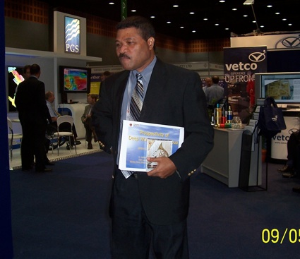
This photograph is of Stanley at a conference somewhere working to interest people in investing in PNG petroleum resources.
Brian Robertson
Site owner
My name is Stanley Pono. I come from Rei village on Lou Island in the Manus Province. I attended primary school on my island, high school at Kambubu, East New Britain Province and Aiyura National High School, Eastern Highlands Province before entering the Science stream at the University of PNG.
At an early age I always wanted to be a builder but my parents encouraged me to do something else. At Aiyura we got a visit from a group of students from the University of PNG Medical School. They introduced us to the different medical fields and one of these was Psychiatry—all about studying and treating mental disease. I was so impressed just by the name that from then on I made up my mind to be a brain doctor. I retained this ambition until I reached University.
During my second year at UPNG I was exposed to the other science fields and found Physics very fascinating but one of the most difficult so I challenged myself to take it up and graduated with a bachelor of science in 1983 majoring in Physics. I was also interested in teaching and successfully completed a one year post-graduate diploma in education also at UPNG and graduated in 1985. You will note that I kept changing my field of interest through days at school and University as I continued to learn and discover new things. I also learned then, that one should never stop learning, as this is the key to success.
I taught science and mathematics at secondary schools which I enjoyed very much for about 3 years but I thought I was missing something more challenging so I joined the Geological Survey, Department of Mineral s and Energy as a Trainee Petroleum Geophysicist. I was given a choice to become a Volcanologist, someone who studies volcanoes including their formation, signs of eruption and other aspects of activity or to become a petroleum geophysicist. A petroleum geophysicist is someone who uses measurements of gravity, of magnetic fields, radioactivity, heat flow, electrical current and seismic data—in the search for oil & gas. I chose to become a petroleum geophysicist in 1988. Gas had just been discovered at Hides and Oil at Kutubu and PNG was planning for construction and first production and eventually export of oil in 1992. It was an exciting time to be one of the first to be trained as a petroleum geophysicist in PNG.
I was attached through a fellowship scheme to the hydrocarbon group at the South Pacific Geosciences Technical Secretariat in Fiji in my first year of work with the department. On my return I was sponsored by Pecten International Company, a subsidiary of Shell, to study geophysics and the technology of petroleum exploration at Pecten’s offices and at the University of Houston, Texas, USA. I worked primarily on computer processing and the interpretation of geophysical data. That was a real eye opener to the leading edge technology of oil and gas exploration.
Geophysics is the main field of science used for exploring and learning about the earth as a whole and one of the most important tools for exploring near the earth’s surface.
A Geophysicist needs different geophysical methods, or tools, to solve different kinds of problems. Different geophysical tools measure different physical properties. (Refer to paragraph 4 above)
These methods can tell something about the shape of the earth, shape and size of sediments, distribution of certain rock types, age of rocks, location of minerals, and the liklihood of oil and gas accumulation.
Of all the methods used the seismic methods are the most important. There are a variety of applications using seismic methods but it takes many people and is expensive.
A great depth of knowledge and skill is required for this type of work. The oil industry is a risky business. Much of the risk arises because science has not yet discovered a direct method of finding oil and gas, or of assessing the quantities of oil and gas which the earth may contain. What is relied on is the geophysicists skill in interpreting the sciesmic data.
These indirect methods for exploring for oil and gas methods—both geological and geophysical do not indicate the presence of oil or gas itself, but only the geological situation where accumulations of petroleum are possible. All geophysical methods, involve taking physical measurements at or near the surface of the ground, and then we try to interpret the measurement in terms of what might be below. Unfortunately, because there is no one-to-one relation between the physical measurement at the surface and the presence of petroleum at depth, this interpretation is often wrong. As a result the oil industry drills a large number of dry (unsuccessful) wells The task of a petroleum geophysicist is to set out and understand geophysical methods, and to try to improve the odds, for even a modest improvement, in the liklihood of finding oil or gas, would be of major economic significance.
I returned from my studies in the US and armed with my new knowledge and skills and I joined Geco-Prakla Geophysical Company, now Western Geco, one of the major geophysical services companies in the world, as a Field Geophysicist. This took me to the most remote places through rivers, swamps, lakes, mountains in the Western, Gulf, Southern Highlands and Sepik Provinces, PNG and even to the desert of Tunisia in North Africa.
We used the seismic method as the main tool to map the sub-surface for oil and Gas on behalf of companies before they drilled for oil and gas. In this method we use artificially generated energy waves (sound waves) from explosives on the ground surface or very large vibrating trucks over accessible areas like the desert in North Africa. The idea is to make a bang on the ground surface and listen for the (echo) waves/disturbance/signal bouncing off the different layers under the ground and record the time for the signal/wave to travel from the ground surface and bounce off the different rock layers and back to the surface. From this an image or a map of the subsurface can be made.
I did not stop there as I then joined the Department of Petroleum and Energy (DPE) and left for Norway to learn more of the Oil and Gas business management and operations. After that I decided to go back to school and I chose to go to the University of Dundee, Scotland, UK where I completed a Degree of Master of Science in Energy Studies in 2000. My thesis was titled “Market Prospects for PNG Natural Gas”. This includes the prospects for the massive PNG Liquefied Natural Gas (LNG) Project now underway. A copy of my thesis can be found in the New Guinea Collection of the UPNG Library and in the DPE Petroleum Archive.
My job at the DPE involved the assessment and promotion of PNG’s oil and gas resource potential to investors all over the world. This took me to places like, USA, Canada, UK, Spain, Australia and Singapore. In this job you get to see the world and the travelling never stops!
I left DPE in 2006 and joined Fugro, also a major geophysical services company. During that year Fugro working together with DPE carried out the largest offshore seismic survey in the southern waters of PNG. This was to promote this part of PNG to exploration companies.
I am now working for myself as a consultant to the mining and petroleum industry. During my free time I help my communities back home on their cocoa project. I enjoy working with my communities and someday soon I may decide to return home where I am needed most. I also like to listen to country & western and rock music and love fishing and hunting. I like the outdoor life.
Stanley Poso’ol Pono